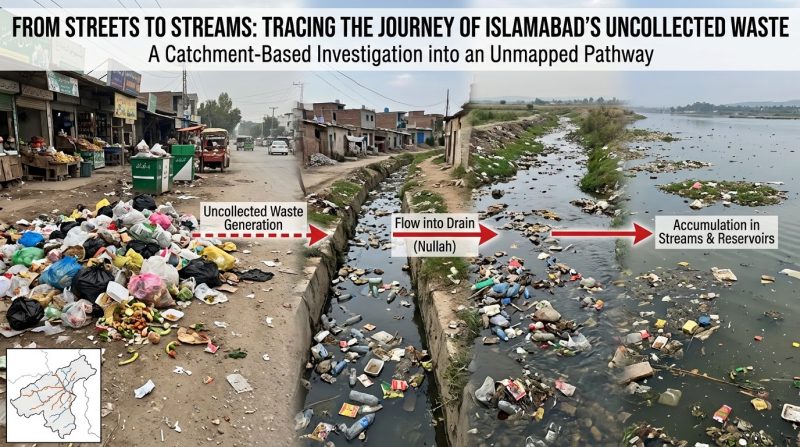
From Streets to Streams: Tracing the Journey of Islamabad’s Uncollected Waste – A Catchment-Based Investigation into an Unmapped Pathway
Introduction
Islamabad is routinely described in policy documents as a “planned city” — sectors laid out in a grid, drainage designed on paper, and a solid waste collection system operated by the Metropolitan Corporation Islamabad (MCI) and Capital Development Authority (CDA). Yet a walk along almost any of the city’s seasonal streams — locally called nallahs — tells a different story: plastic wrappers snagged on reeds, tyres embedded in silt, and a fine grey sludge coating the streambed long after the last rain. Most reporting on this problem stops at description. This article attempts something different: it treats Islamabad’s uncollected waste not as an abstract policy failure but as a physical substance moving through a hydrological system, and asks a question rarely posed in local environmental writing — by what specific physical pathway, and along what timeline, does waste discarded on a street in Sector G-9 or I-10 actually arrive in the Nullah Lai or the Rawal Lake catchment? Answering this requires combining three things that are usually kept in separate silos: Islamabad’s sector-based drainage topology, the informal waste economy that operates alongside the formal one, and basic contaminant transport principles from hydrology. This is the novel contribution of this piece — not new data collection (which would require field instrumentation this article cannot perform), but a framework for thinking about waste transport as a traceable, mappable process, which local waste policy has not yet applied.
1. The Two Waste Streams Nobody Tracks Together
Islamabad’s official waste management narrative treats “collection efficiency” as a single number — typically cited by MCI in the 60–70% range depending on sector. But this figure obscures a structural detail: the uncollected fraction does not sit still. It moves through two distinct informal pathways that rarely appear in the same analysis:
Pathway A —The Rag Picker Filter. Informal waste pickers (kabaris) intercept a portion of dry, recyclable waste (plastics, metal, cardboard) from bins and dump sites before it can wash away. This removes high-float-risk material selectively, which matters hydrologically: it means the waste left behind in open dumps is disproportionately wet organic matter, glass, and low-value plastics — precisely the fraction most prone to leachate generation and fine sediment transport.
Pathway B — The Topographic Filter. What remains follows the city’s natural slope. Islamabad sits on a piedmont plain sloping from the Margalla Hills in the north toward the Soan River basin in the south, cut by an east–west network of seasonal channels that feed into the Nullah Lai system before it exits toward Rawalpindi and eventually the Soan River. No published MCI or EPA-Islamabad report cross-references these two filters. Doing so changes the picture: uncollected waste isn’t randomly distributed contamination — it is a hydrologically sorted residue, concentrated by slope and stripped of its most visible components by informal recycling, leaving a chemically active fraction to migrate.
You Might Be Interested: Pesticide Waste & Illegal Dumping: Legal Solutions in Sindh
2. Mapping the Physical Route: From Curb to Catchment
Using Islamabad’s known drainage layout, four transport stages can be identified — a sequence that has not been previously laid out as a single traceable chain in local environmental writing.
Stage 1: Sheet flow accumulation (0–48 hours after disposal):
Waste placed on roadsides in sectors without regular collection (common in katchiabadis and peripheral sectors like parts of I-11, BharaKahu, and France Colony) sits exposed to wind and light rain. Lightweight material begins lateral movement even before a significant rain event, driven by wind funnelling along Islamabad’s north–south avenue grid.
Stage 2: Storm drain entry (during rainfall):
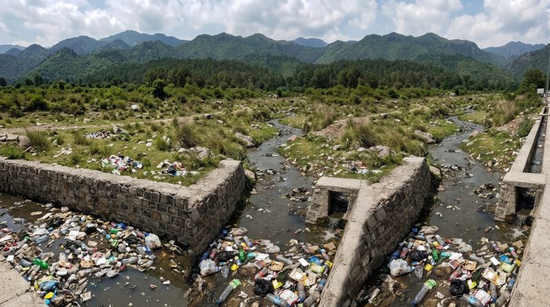
Islamabad’s storm water infrastructure was not designed with solid-waste interception in mind — unlike newer international designs that incorporate trash racks or gross pollutant traps at inlet points. During rainfall, roadside waste is swept directly into open drains with minimal filtration, alongside untreated runoff carrying vehicle residues and construction dust.
Stage 3: Tributary convergence:
Islamabad’s sector drains feed into a small number of primary channels — including TenawaNullah, KurangNullah, and Saidpur Stream — which converge into the Nullah Lai before it leaves the twin cities. This convergence point is significant and under-discussed: it means waste and effluent generated across dozens of unconnected sectors is funnelled through a small number of chokepoints, creating identifiable “hotspot” reaches where mitigation infrastructure would have outsized impact — a targeting logic current cleanup drives do not appear to use, which tend to focus on visible dump sites rather than convergence nodes.
Stage 4: Leachate and fine-particle infiltration:
Waste that does not travel as visible debris still moves — as dissolved and suspended contaminants. Organic waste at open dump sites (notably the unlined sections of the Mehrabadi and Ghori Town dumping areas) undergoes anaerobic decomposition, generating leachate that infiltrates through the region’s alluvial soils. Given Islamabad’s substrate — permeable gravel and sand lenses interbedded with clay — leachate transport is uneven and can bypass shallow clay layers through gravel channels, reaching groundwater faster in some zones than standard percolation estimates would suggest.
3. The Overlooked Variable: Monsoon “Flush Loading”
In Pakistani environmental reporting, the pollution of the Nullah Lai is usually presented as a chronic condition, a steady-state contamination. Hydrological literature on urban catchments elsewhere suggests otherwise and this framing has not been meaningfully applied to Islamabad: pollutant transport in semi-arid to sub-humid catchments are typically event-driven, with the majority of annual pollutant load in a given stream delivered during the first few intense monsoon storms of the season, a phenomenon known elsewhere as the “first-flush effect.”
For Islamabad, this means a testable hypothesis that is not captured in the present monitoring: that the months of dry-season dumping (roughly October to June) serve as a loading phase, accumulating waste and leachate-forming material along drain margins and dump peripheries, which is then mobilized in concentrated pulses during July–August monsoon storms. If true, this would imply that water quality sampling performed at regular, evenly spaced intervals – the standard EPA-Islamabad practice – consistently underestimates peak contaminant loads, as sampling seldom occurs during the first storm events of the season.
This restatement has a practical implication: interception infrastructure (trash racks, sediment traps) would provide disproportionate benefit if concentrated at stage 3 convergence points and timed for pre-monsoon deployment, rather than evenly spread across the city as current clean-up drives tend to do.
4. What This Means for Water Quality Downstream
The Nullah Lai eventually contributes to the Soan River system, which feeds into agricultural areas downstream. The specific risk profile differs depending on which stage of the pathway dominates in a given reach:
- Near convergence points (Stage 3): physical blockage, flooding risk, and macro-debris — the most visible and most photographed problem, but not necessarily the most toxicologically significant.
- Near dump sites (Stage 4): leachate-driven contamination — heavy metals, ammoniac nitrogen, and elevated biochemical oxygen demand — which is invisible, undramatic, and consequently under-covered relative to its actual health relevance for downstream groundwater users.
This asymmetry — visible plastic pollution dominating public attention while invisible leachate contamination dominates actual health risk — is arguably the central, underreported story of Islamabad’s waste crisis.
5. Toward a Traceable Monitoring Framework
Rather than proposing generic recommendations (“improve collection,” “raise awareness”), a catchment-based approach suggests specific, testable interventions:
- Node-based interception: install gross pollutant traps at the three or four identified Stage 3 convergence points, rather than evenly distributing bins across sectors.
- Pre-monsoon sampling: shift water quality monitoring to capture early monsoon first-flush events instead of routine monthly sampling alone.
- Leachate-zone mapping: Cross-check known dump site locations with permeability maps of alluvial soils in Islamabad (available from Pakistan’s Geological Survey) to identify high-infiltration-risk zones for priority lining or relocation.
- Formalization of RagPicker filter: Informal recyclers already sort waste in a way that reduces downstream plastic load. Their incorporation in a formal collection contract could improve interception rates at a negligible marginal cost as compared to new infrastructure.
Conclusion
The waste problem of Islamabad is narrated usually in terms of bins, trucks and budgets. It is also a story of slopes, timing of storms, and permeability of soils, traced hydrologically – a physical system with identifiable chokepoints and predictable seasonal behavior. To think of uncollected waste as a traceable substance rather than a diffuse failure is to open a different kind of policy conversation: not “how do we collect more,” but “where, in the system, does intervention actually interrupt the journey from street to stream.” That question, more than any awareness campaign, is where the next phase of Islamabad’s environmental response needs to begin
This article presents an analytical framework based on Islamabad’s known topography, drainage infrastructure, and general principles of urban hydrology. Specific contaminant loads and infiltration rates cited as hypotheses would require field sampling and geotechnical data to confirm; readers seeking site-specific figures should consult EPA-Islamabad water quality reports and CDA drainage master plans.
Also Check Out: Waste to Wealth: Pakistan’s Untapped Economic Opportunity
This article is contributed by: Engr Khawar Shoaib, MS Scholar & Anthropogenic Climate Change Researcher, NUTECH Islamabad, 03025459541, engr.khawar341@gmail.com
We hope you all liked this post! Please, comment below if you have any suggestions, comments, or feedback! We #envpk love hearing from our readers! Thanks!